Marshall Lake Project
Marshall Lake is a joint venture project between Rainy Mountain Royalty Corp. (31.25%) and Copper Lake Resources Ltd. (68.75%). Copper Lake has an option to increase its JV interest to 75% in the project by spending a further $1 million in exploration expenditures ($4 million in total) by July 2018 and Copper Lake has an additional option to increase its JV interest to 87.5% by incurring such additional expenditures as are necessary to take the project to bankable feasibility stage.
Robert S. Middleton, P.Eng., is acting as the Rainy Mountain’s Qualified Person for the current stage of its Marshall Lake Property project,in accordance with regulations under NI 43-101.
The Marshall Lake property consists of 9 claims plus 86 leased claims (804 claim units) with an area of 163.8 km and is located approximately 252 km northeast of Thunder Bay, Ontario.
 |
 |
| Marshall Lake Claim Map | Marshall Lake Model |
 |
 |
| Gazooma Zone | VTEM Survey |
Assay Results
Click here for: Drill Hole Assay Results
Technical Reports
January 27, 2010 Marshall Lake Technical Report
June 7, 2016 Marshall Lake Technical Report
October 3, 2023 Marshall Lake Technical Report Effective August 12, 2023
History
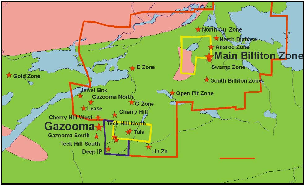
Positive results were produced by the spring 2007 drilling program, highlighted by assays such as 2.45% copper, 47.6 g/tonne silver over 14.8 metres; and, 1.67% copper, 32g/tonne silver, 0.37g/tonne gold over 22.50 metres at the Gazooma Zone. The Gazooma Zone has now been linked by a continuous IP anomaly to the Teck Hill occurrence 600 metres to the southeast, and has led to optimism that follow-up drilling could generate both volume and grade necessary for economic feasibility.
In addition to proving this potential, new discoveries were also made. The first hole drilled at an occurrence called North Gazooma intersected 0.71% copper over 31.9 metres, and drilling a VTEM anomaly 4 km to the east, south of the Billiton occurrence, produced assays of 0.94% copper, 1.03% zinc, 49 g/tonne silver over 15 metres.
The 20 hole, 2950 metre diamond drilling program that took place during the months of May and June, 2008 was under very wet conditions, limited drilling of targets in the driest areas only. Many targets were left untested and can only be addressed in winter conditions. 5 anomalies detected in gabbro in the eastern section of the property were drill tested in May 2008. Pyrrhotite sulphides were found to be the cause of the anomalies. 5 anomalies in the volcanic pile were drilled, and again pyrrhotite sulphides were the cause of the anomalies, however, minor zinc sulphides and wall rock alteration minerals found in VMS systems were noted. Therefore, exploration for zinc is continuing in the upper sequence of the felsic volcanics pile near some of the anomalies.
Also in May-June 2008, 10 drill holes were drilled to test the depth extension of the Gazooma, Teck Hill and North Gazooma areas. 3 holes on Gazooma intersected copper zones 100-150m down dip from the original trench exposure and step-out as well as in-fill holes are now being planned.
3 holes drilled in section on Teck Hill, on the IP anomaly trending to Gazooma, intersected copper mineralization thereby further demonstrating continuity between Gazooma to Teck Hill. Follow-up mise-a-la-masse geophysical surveys will be used to trace these lenses in order to design follow-up drilling. 1 hole was also drilled 100 m south of the original Teck Hill discovery made in 1954 and 1 m of massive chalcopyrite was intersected at 93 m in the hole followed by another 30 m of stringer and disseminated chalcopyrite. This gives over 140 m of sulphides down dip from the surface showing and confirmation of a wide spread copper zone within the felsic (rhyolite) volcanics. 3 holes completed on North Gazooma as follow-up on hole GAZN-07-02 (0.71% Cu over 32m) drilled on in March 2007, confirm both lateral and depth continuity of mineralization to 85 metres.
An estimated 3000-4000m drill program is required on the Gazooma-Teck Hill area to initiate a resource calculation.
