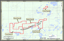
The geology of the Shebandowan Camp is similar to that of Timmins, Kirkland Lake, Noranda, and Val d'Or because Shebandowan is part of the Abitibi greenstone belt. Access to these properties is via Highway 11, 110km west of Thunder Bay. Lumber roads cross all of the claim groups connecting to Highway 11. Power lines and the CNR rail line parallel Highway 11 within 5km of the north property boundaries of the Burchell and Obadinaw claims.
Exploration has found a new style of mineralization on the Hamlin-Deaty claims in the form of an Iron Oxide Copper Gold (IOCG) system that is Timiskaming in age and is similar to deposits found in Brazil.
 |
Shebandowan Group of Properties Location Map JPG: 382 KB |
| Property | Total claims * | Target | Joint Venture Partner | Operator | Rainy Mountain's interest ** |
| Hamlin | 77 | Au, Cu, Zn | Xstrata Canada Corporation/Mega Uranium Ltd. | Xstrata Canada Corporation | 24.5% |
| Deaty Creek | 79 | Au, Cu | Xstrata Canada Corporation//Mega Uranium Ltd. | Xstrata Canada Corporation | 24.5% |
| Clay | 112 | Au, Cu, Zn | Fairmont Resources Inc./Mega Uranium Ltd. | Fairmont Resources Inc. | 100.0% |
| Powell | 86 | Au, Ag | Fairmont Resources Inc./Mega Uranium Ltd. | Fairmont Resources Inc. | 50.0% |
| Rossmere | 224 | Au | Marshal Lake Mining Plc/ Drift Lake Resources Inc. | Drift Lake Resources Inc. | 50.0% |
| All info as of November 17, 2011 | |||||


